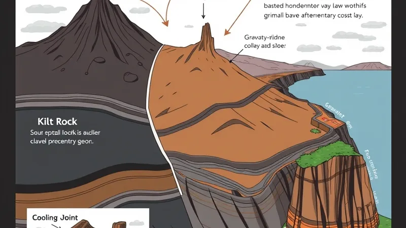
Why do the Quiraing, the Storr and Kilt Rock look different?
Trotternish combines resistant volcanic basalt above weaker sedimentary rocks, large-scale slope failure and coastal erosion. Those ingredients produced related but distinct landforms: the Quiraing and the Storr are landslide landscapes, while Kilt Rock’s pleated appearance chiefly reflects fractures formed as basalt cooled.
The distinction matters. A detached pinnacle below an escarpment tells a different story from columns still exposed in a coastal cliff. The British Geological Survey provides geological mapping and regional interpretation for understanding these relationships.
A compact feature–process–evidence comparison:
- Quiraing — landsliding: displaced rock masses, steep scarps and pinnacles beneath the plateau edge.
- Storr — slope failure and weathering: cliffs above a disrupted slope, including the separate Old Man of Storr pinnacle.
- Kilt Rock — cooling joints and coastal erosion: vertical divisions in basalt above sedimentary rocks.
These are features to recognise, not a promise that every detail will be visible. Cloud, viewing angle and safe access all affect what a visit reveals.
What lies beneath the basalt of Trotternish?
The basalt overlies a sedimentary sequence that includes sandstone, mudstone and shale. Basalt is cooled lava; sedimentary rocks formed from accumulated material such as sand and mud. Their distribution varies, so the peninsula is not a perfectly uniform layer cake.
BGS geological mapping is the appropriate reference for local rock boundaries. The important contrast is between relatively resistant lava rocks and underlying beds that can be weaker or more readily eroded.
Instability does not require a single slippery layer. Rock strength, fractures, the arrangement of beds, groundwater pressure and erosion at a slope’s foot can interact. Water can reduce stability within a fractured slope, while loss of support below can allow overlying masses to move under gravity.
How did landsliding shape the Quiraing?
The Quiraing formed through gravity-driven displacement of rock masses along Trotternish’s escarpment. An escarpment is a steep slope or cliff marking a pronounced change in ground level. Landsliding broke up the slope below it, leaving scarps, separated masses and distinctive pinnacles.
This is not volcanic construction: lava supplied the basalt, but landsliding rearranged the rock after it had solidified. Nor should the broken landscape simply be described as carved by a glacier.
NatureScot’s geodiversity and protected-site resources provide context for the Trotternish landslides. Names such as the Prison, Needle and Table help orient visitors, but their shapes alone do not establish the precise movement history of each feature.
The most useful visual question is whether you are looking at the main plateau edge or rock displaced below it. That distinction explains more than imagining a single dramatic collapse.
How did landsliding shape the Storr and the Old Man?
The Storr escarpment and the Old Man of Storr are different parts of a landslide landscape. The Storr forms the high cliff backdrop; the Old Man is a separate pinnacle below it.
Slope failure disrupted the ground beneath the cliffs, and subsequent weathering helped modify exposed rock. Weathering means breakdown in place, through processes such as water entering cracks and freezing. Erosion then removes loosened material.
The regional interpretation represented by BGS and NatureScot connects this landscape with Trotternish’s broader landslide belt. It does not require an exact reconstruction of how every individual block travelled.
The difference between Storr and Quiraing geology is therefore not a completely different origin. Related processes acted at separate locations, leaving different arrangements of cliffs, displaced masses and surviving pinnacles. That is not evidence of a simultaneous peninsula-wide collapse.
Is Kilt Rock another landslip?
Kilt Rock’s characteristic vertical pattern is primarily columnar jointing in basalt, not the same landslide mechanism. As lava cooled and contracted, fractures developed, dividing the solid rock into column-like sections.
These cooling joints help explain the resemblance to pleats. Sedimentary rocks beneath the basalt are exposed in the coastal cliff, illustrating the contrast in materials described in BGS geological resources.
Marine erosion works on the cliff, and local rockfall can alter it. Neither process should be confused with the large displaced rock masses at the Quiraing and Storr.
Nearby Mealt Falls is a separate water feature: its falling water does not explain the basalt columns. Flow, visibility and access to the viewpoint should never be assumed.
What roles did ice, water and weathering play?
The modern landscape records several processes, rather than a single event. Lava emplacement supplied the basalt; glaciation reshaped the wider terrain; landsliding displaced rock; weathering weakened exposed surfaces; rivers and the sea removed material.
Ice erosion and changes in support after ice retreat can influence slope stability. However, applying that explanation to a particular landslide requires local evidence, not a universal claim that melting glaciers caused every collapse. NatureScot’s geodiversity interpretation provides the relevant regional context.
Water also has different roles: groundwater can affect stability within a slope, streams transport sediment, and waves attack the coast. Rain during a visit is not evidence that a particular rock mass is moving.
How can visitors explore these geological features responsibly?
Viewpoint visits, short out-and-back walks and full hiking routes are not interchangeable. A designated viewpoint may reveal the broad geology without committing you to steep mountain paths, but it does not guarantee access or clear views.
The Storr ascent is steep and exposed. The full Quiraing circuit is graded Hard by Walkhighlands, with terrain near cliff edges. Turning back early does not automatically make the ground already crossed easy or sheltered.
Wind, mud and poor visibility can change the suitability of either walk. Keep away from cliff edges and avoid lingering beneath unstable rock faces. The Scottish Outdoor Access Code sets out the principles of responsible access, including respecting land management and caring for the environment.
For snow-related Quiraing road closures and other restrictions, consult Highland Council and follow current closure notices rather than a fixed itinerary. A road being open does not establish that a walking route is suitable.
Can you explore Trotternish without a car?
A Portree base, suitable public transport and guided excursions can support a car-free visit, but reaching Skye and exploring Trotternish are separate tasks. Start with our guide to getting to Skye for travel from Inverness or Edinburgh, then consider where to stay in Portree.
Use official Stagecoach timetables to establish actual stops, seasonal operation and return options. A service through a nearby settlement does not necessarily provide safe or convenient trailhead access. Build your walking plan around the return journey, not just the outward bus.
For organised travel, compare a Skye day trip with a multi-day tour. Day trips and three-to-five-day itineraries offer different amounts of time, but neither guarantees particular stops.
Isle of Skye Guide is an independent editorial and affiliate guide, not a tour operator. Current tour prices in pounds and ratings belong in GetYourGuide widgets on tour pages. Weather and access can remove stops from any proposed programme.
What should visitors know about Trotternish geology?
The key distinction is between landslide landforms and cooling structures in volcanic rock. These answers summarise the interpretation above.
Is the Quiraing still moving?
Parts of a landslide complex can remain susceptible to movement, but that does not mean every feature is continuously moving. A claim about current activity at a particular location needs site-specific evidence; no movement rate is assumed here.
Are the Storr and Quiraing part of the same landslip?
They belong to the same broader Trotternish landslide belt. They are separate landslide landscapes, not evidence of a single simultaneous collapse.
Is Kilt Rock volcanic?
Its columned upper rock is volcanic basalt, formed from cooled lava. Sedimentary rocks lie beneath it. The vertical pattern chiefly reflects cooling fractures.
Can I understand the geology without completing a hike?
Yes. Where access and visibility permit, a viewpoint can reveal the relationship between cliffs, columns and displaced rock. Understanding the broad pattern does not require reaching every named formation.
Are these stops guaranteed on a Skye tour?
No. Wind, snow, poor visibility, road restrictions or site closures can change an itinerary. Even a planned viewpoint stop may be unavailable.
Sources
- British Geological Survey: geological mapping and regional resources for rock types, structure and landslide interpretation.
- NatureScot: geodiversity and protected-site documentation relevant to Trotternish’s landslide landscapes.
- Walkhighlands: Skye walks: route descriptions, including the Quiraing circuit; walking guidance is distinct from geological interpretation.
- Highland Council: official road, winter maintenance and access information.
- Stagecoach: official bus timetables and service information for planning outward and return journeys.